wolfwolfwolf
You are viewing an archived copy of the once beloved Trail Nerds Website.
For new race information updated frequently please visit www.wycowolfpack.com
wolfwolfwolf

Bad Ben's Trail Running Site

Landahl Park
Home | Weekly-Schedule-Group-Runs | Trail-Nerd-Events | JOIN-Membership | Trail Nerds Facebook | MudBabe Facebook | TRAILS | Advice & Info | LINKS | News | T-Shirt Etiquette | About Us | KC Running Site | Contact Us | Mud Babes | Topeka Trailrunning | Texas Trail Nerds | OZARKS Trail Nerds | Dirt Dawgs | Trail Nerd World | ALL Events

MapQuest Map to Landahl Park

landahl_location2.gif

Landahl Park Reserve is a great trailrunning resource.  Please follow these rules when running on the trails:
 
  1. Do not wear headphones; there are bikes on the trails.
  2. Step aside for MTB riders.
  3. Never scare animals.
  4. Always yield to horses and announce your arrival way in advance, if approaching from the rear.
  5. Run on open trails, only.
  6. Leave no trace!  There are restrooms available, also.
 
Click for a TRAIL MAP

Directions:
Landahl is east of KCMO. Directions: Take I-70 to Exit 20 and go north on 7. After a couple of miles turn right on Argo road. You will see a shooting range on the left. Go past that for a mile or so. Look to the left for a gravel parking lot. The parking lot is across from an archery range with a little concrete bathroom building.

Map to Landahl

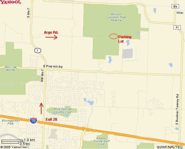
The former Lake City Park Reserve was renamed for William Landahl, the countyıs first park director.
 
Landahl Park Reserve is a 1,397-acre county park in eastern Independence, east of Missouri 7 and south of Truman Road. The park contains almost everything Landahl worked to provide county residents. It has hiking trails, a ball field, soccer fields, horse trails, fishing, picnic shelters, rest rooms, camping sites and even a ski trail for the winter months.
 
More information can be found on the Earthriders MTB site.

Bad Ben's Trail Running Site